Port Louis Maps and Orientation
(Port Louis, Mauritius)
Mauritius is an island located some 2,000 km / 1,245 miles off the western coast of Africa, to the east of
Madagascar and within the Indian Ocean. Its capital of Port Louis lies on the western side of the island, where a series of natural harbours carve into the land mass. Port Louis has a spectacular backdrop, sitting as it does beneath the Le Ponce and Pieter Both mountain peaks. As one descends from the Central Plateau to the low-lying urban hub, the visual impact is nothing short of sublime.
Historically, Port Louis has been labelled as an undesirable place to live. Its low elevation beneath the higher interior of Mauritius has encouraged those who can, to live outside the city. The professional classes of the island tend to live in Central Plateau towns such as Quartre Bornes, Moka, Vacoas and Rose Hill.
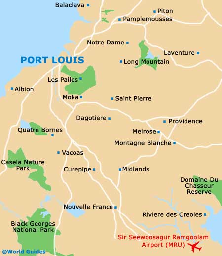
Maps and Orientation of the City
Port Louis is a well-organised city, with streets laid out in grid-like fashion. The pace can feel a bit frenetic compared to the coastal resort areas of the island, but it is still manageable. Large motorways run around the perimeter of the island and cut directly across from Port Louis on the west, leading to numerous smaller towns dotting the east coast.
Getting around the capital of Port Louis is fairly easy if you have a good street map. These can be obtained from the Ministry of Tourism outlet at the Air Mauritius Centre on John Kennedy Street. You can also find a branch of this tourism office at the airport. Useful maps of the entire island are also available, making it quite easy to drive yourself around Mauritius if you are so inclined.
- Belle Mare - 45 km / 28 miles (one hour, east)
- Centre de Flacq - 38 km / 23 miles (50 minutes, north-east)
- Grand Gaube - 29 km / 18 miles (45 minutes, north-east)
- Mahebourg - 49 km / 30 miles (one hour, east)
- Moka - 12 km / 7 miles (15 minutes, south)
- Quarte Bornes - 13 km / 8 miles (15 minutes, south)
- Riviera Noire - 39 km / 23 miles (50 minutes, south)
- Saint Pierre - 15 km / 9 miles (20 minutes, east)
- Vacoas - 19 km / 11 miles (25 minutes, south)
Map of Mauritius

Map of Port Louis